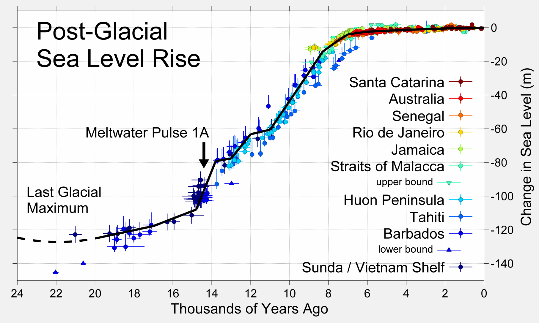
The findings corroborate other papers demonstrating many South Pacific islands are not sinking and that claims they are due to man-made global warming driven sea level rise are opportunistic.
According to the authors,
Upon correction for isostatic island subsidence, we find that local [relative sea level] was at least ~1.5±0.4 meters higher than present at ~5.4 [thousand years ago]. Later, minor amplitude variations occurred until ~2 [thousand years ago], when the [relative sea level] started dropping to its present position with a rate of ~0.4 mm/year.The authors attribute the drop in sea levels to post-glacial rebound since the last ice age, "which is still significantly affecting the present-day vertical position of the mean sea surface and the sea bottom."
Constraining Mid to Late Holocene relative sea level change in the southern equatorial Pacific Ocean relative to the Society Islands, French Polynesia
Rashid Rashid et al
Precisely quantifying the current climate-related sea level change requires accurate knowledge of long-term geological processes known as Glacial Isostatic Adjustments (GIA). Although the major post-glacial melting phase is likely to have ended ~6-4 ka BP (before present), GIA is still significantly affecting the present-day vertical position of the mean sea surface and the sea bottom. Here we present empirical rsl (relative sea level) data based on U/Th dated fossil corals from reef platforms of the Society Islands, French Polynesia, together with the corresponding GIA-modelling. Fossil coral data constrains the timing and amplitude of rsl-variations after the Holocene sea level maximum (HSLM). Upon correction for isostatic island subsidence, we find that local rsl was at least ~1.5±0.4 m higher than present at ~5.4 ka. Later, minor amplitude variations occurred until ~2 ka, when the rsl started dropping to its present position with a rate of ~0.4 mm/year. The data match with predicted rsl curves based on global ice-sheet chronologies confirming the role of GIA-induced ocean siphoning effect throughout the mid to late Holocene. A long lasting Late Holocene highstand superimposed with second order amplitudinal fluctuations as seen from our data suggest that the theoretical predicted timing of rsl change can still be refined pending future calibration.

At least means more than 1.5 meters, probably 2 meters the same as the drop in sea level for peninsular Malaysia.
ReplyDelete